Located in the southern part of Peninsular Malaysia, the Johor region is home to one of Malaysia’s most treacherous hills and close to Singapore. It is a hilly region and as such has a sequence of distinct hills in all aspects except that they are all found in Johor. Hiking will not only train you, but will also assist enhance the functioning of your heart and lung. Take the advantage to explore to these mountain with your friends in Johor on this coming weekend!

1. Gunung Pulai, Johor
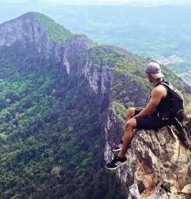
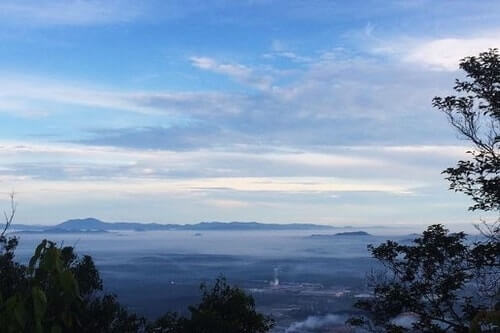
Also known as Mount Pulai, Gunung Pulai is one of Johor’s most famous hiking places. In this part of the globe, the flora and fauna discovered in Mount Pulai attracts many hikers. Also appealing to most hikers is the variety in wildlife here. You will have the opportunity to see and admire several waterfalls on your way up, as you can have a picnic on top as well. The 654m elevated mountain includes a forest reserve of about 80 square kilometers and is the nearest region between Johor Bahru and Singapore. Gunung Pulai is drawn by many Singaporeans and other tourists because they think there is a historic link between Mount Pulai and Singapore.
Tips To Get To Gunung Pulai:
Drive along Jalan Sawahto JIn TM Gn Pulai, along the manner you will see
many quarries of sand and oil plantations. You will arrive at the entrance of
Kg Sri Gunung Pulai on your left after about 10 minutes of driving after 11 km.
You can’t fail to notice the most evident landmark when driving to Gunung Pulai
that says you’ve arrived. It is the teacup landmark bearing the name of Anggun
Café and the highway leading to Gunung Pulai’s beginning trailhead.
Location: Gunung Pulai Recreational Forest, Kulai 81000, Malaysia
Elevation: 654 m
Prominence: 486 m
Mountain range: Titiwangsa Mountains
2. Gunung Panti
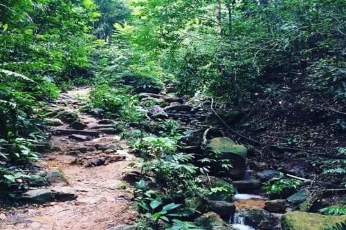
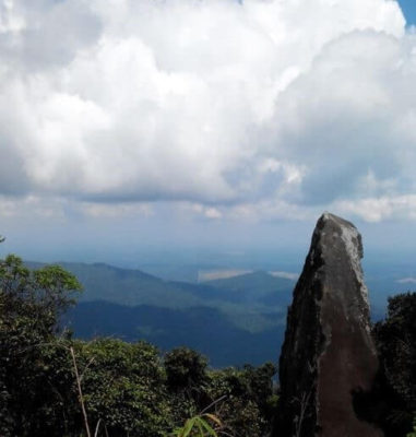
It is a treacherous but beautiful mountain that can be seen from as far as the waterfalls of Kota Tinggi. It is 485 meters high and its peak seems to be capped with an enormous bolder that provides it an unmistakable identity. This is the ideal set-up for any hiker who wants to take on the daunting challenge of reaching their peak and finding out what’s in store. The mountain provides you a complete circle view of the surrounding region once you reach the peak, not to mention the lovely countryside that awaits you in the form of flora and fauna at the top. It will take any hiker about 2.5 hours to climb and 2 hours to descend and it is not very taxing to climb this mountain.The best part of the walk is climbing rock where you need to use ropes to lift yourself and position your foot strategically. With all the friends helping you, slow and steady. Make sure you’re dressed as it can get wet sometimes and you don’t want to get caught in the mess. Its imposing outlines stand out because it challenges any seeker of adventure to try it out!
Tips To Get To Gunung Panti:
To reach its foothills, it is about 8 km from Kampong Batu Ampat to drive from Kota Tinggi to Air Terjun passing Kampong Batu Ampat, Air Terjun or Kota Rainforest Resort. Before reaching Kota Rainforest Resort, the path you should look for should be on your right and about 50 meters away. Take the dirt road and in no time you will reached the fot of Mount Panti.
Location: Gunung Panti Recreational Forest, 81900, Kota Tinggi, Johor
Elevation: 453 m
3. Gunung Lambak

Gunung Lambak is a twin peaked mountain with a peak of about 510 meters above sea level. Lambak is split into Nanshan and Beishan, which is translated as Flea Mountain or Nanba Mountain. It’s also a bit steeper than Gunung Panti and requires a lot of hiking effort. The path leading up to Lambak Mountain is steadily increasing and rough. Climbers can choose which route to climb because of the advanced hiking paths. It takes about 3 to 4 hours to get from the horn to the top of the mountain.
You can also see a lot of rare plants and animals here! It can give any hiker who wants to conquer the Gunung Lambak a very nice challenge. It is free to climb the mountain as there are no permits or entrance fees.
Tips To Get To Gunung Lambak:
If you want to get to Gunung Lambak in Kluang and use the North-South Expressway, take exit Air Hitam (interchange 244) and then take Highway 50 to Kluang City. You’ll see signs for the Gunung Lambak Recreational Forest on the southwest edge of the city when you’re close Kluang. Hiking Johor.
Location: Gunung Lambak Recreational Forest, 86000 Kluang, Johor
Elevation: 510 m
4. Gunung Belumut
Gunung Belumut has an elevation of up to 1010 metres, almost twice as high as the mountains on this list and about 18 km east of Kluang. Compared to Lambak and Panti Mountains, this mountain is greater and steeper and requires an person all day trekking up and down. It will take about 2 days and one night to create the whole trek for a tiny group.
There are three campsites along the manner to the summit on the trekking path. The first campsite is only a short distance from the mountain base. The best campsite is the one with a flowing stream nearby at the base of the hill. Approximately 20 individuals can be used as campsites on both sides of the bank. On your manner to the summit, the second one is discovered, while the last one is discovered just about 30 meters up the second. With a holding capability of about 12, the second campsite, a 30-minute walk from the summit, is comparatively low. It is protected by trees and has an insufficient supply of water. Further up the mountain is the last campsite and much larger with room for about 20 individuals. It is exposed and can pose risk to lighting strikes. You have to carry a sleeping bag as it’s quite cold up here. In case of anything, it’s also nice to have some mosquito coil, salt and vinegar. Since it is under the Johor Forestry Department’s National Peak Council protection and management, it is necessary to pay for mountaineering. Mountain climbing and the use of the chalet for an overnight stay are charged. To achieve the top, one has to cross a steep mountain of 80 degrees. The region is sufficient for up to six individuals who can stand strongly. Hurry and appreciate your magnificent view!
Tips To Get To Gunung Belumut:
The trip will last slightly over one and a half hours at the Larkin terminal in Johor Bahru, where you take another express bus to Kluang. Take a taxi to Grunung Belumut Park from Kluang Bus Interchange, it may take 30 minutes to get there. Alternatively, you can arrange to take you from either the train station or the bus station to the resort with the resort staff. Hiking Johor.
Location: Gunung Belumut Recreational Forest, Kulai, Johor
Prominence: 953 m
5. Hiking at Gunung Arong
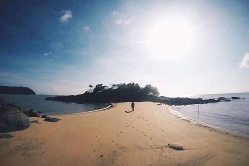
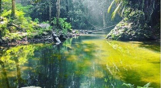
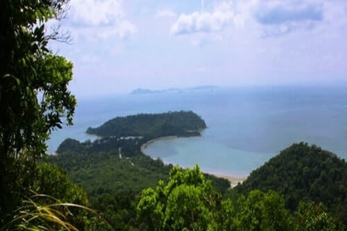
Gunung Arong is a small hill situated in Penisular Malaysia, 273 meters above sea level, in state of Mersing. The stream provides a lot of hikers and adventure seekers maximum pleasure, whose cooling and refreshing impacts are an unforgettable experience. Not only that, it enables you to appreciate the view of the beach, ideal for couple hikers! With a panoramic views of the South China Sea and its neighboring islands, the Gunung Arong peak rewards hikers and trekkers alike. You can also see Pulau Tioman’s magnificent splendor unfolding before your eyes in fine weather. You have to hike for about 2 hours to achieve the peak, which is about 255 meters high. After the walk, at Tanjung Resang Beach, you can always relax. For many hikers, this is a famous destination. Its raw waves and wind create the perfect situation to harmonize with the wild. Be sure to first ask for a climbing license for those who want to hike at Gunung Arong.
Tips To Get To Gunung Arong:
Where there is any public transport to the region, little is known. The best way to get here is by private car or private taxi. The region is between Endau and Mersing. You will see a store selling snacks as a counter for registering. Hiking Johor.
Location: Gunung Arong Recreational Forest, 86900, Johor
How to go to Hiking in Johor with our private taxi service?
We provides a private taxi as your transport to JB because it is very convenient and comfortable. Check out our affordable price here! Travel from Singapore to Johor Bahru now to enjoy your day with our private taxi service. What are you waiting for? Let’s book now with hassle free private taxi Johor Bahru service from JB2SG!
Contact by Phone/Whatsapp: 012-7883383
Contact by Email: kenny@smartouch.com.sg


54 thoughts on “Top 5 Famous Extreme Hiking Spots You Must Go In Johor”
Comments are closed.